I suspect that you might need to use a slightly higher threshold because I still get higher elevation gain when selecting in the graphs even tough it’s closer than before
Thank you so much!
One question,
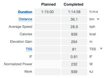
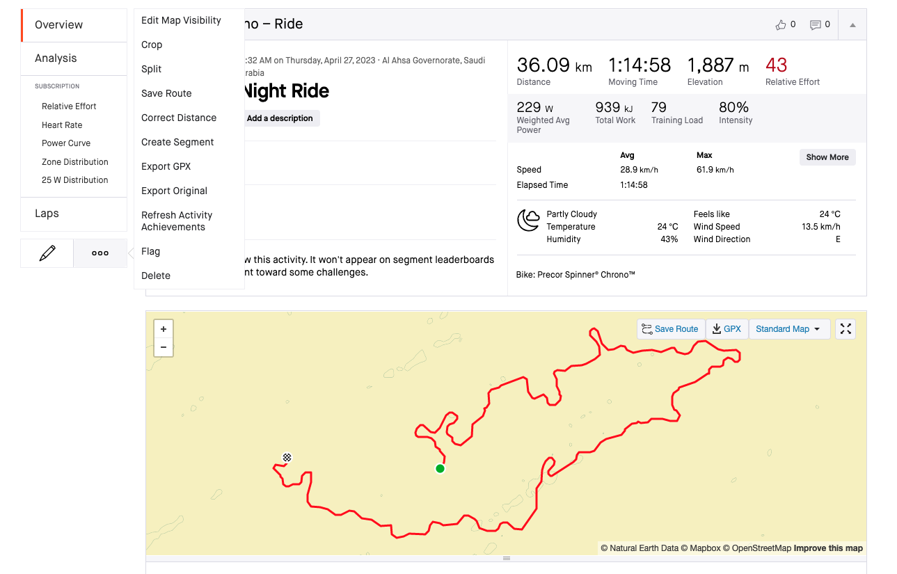
I did an indoor activity (cycling) and the elevation was 264m but when I export it to Strava it changes to 1,800m.
What’s more strange is that on Training Peaks it looks the same as Intervals.icu
Can you help me out?
Have you tried clicking on the three-dot action menu in the left sidebar and select the option to “Correct Elevation.”?
Edit: in Strava
I got that option on the original file but not on the Intervals.icu file, see here:
I can only correct distance.
So you tried importing the Intervals.icu generated fit file to Strava? Maybe try the “Original Fit File” option.
Hi David,
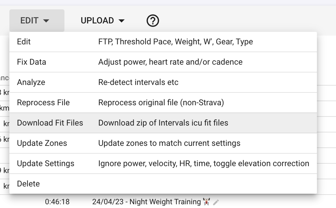
I used the “download fit files (download zip of intervals icu fit files)”, are you referring to the option on top?
Thanks!
Hi,
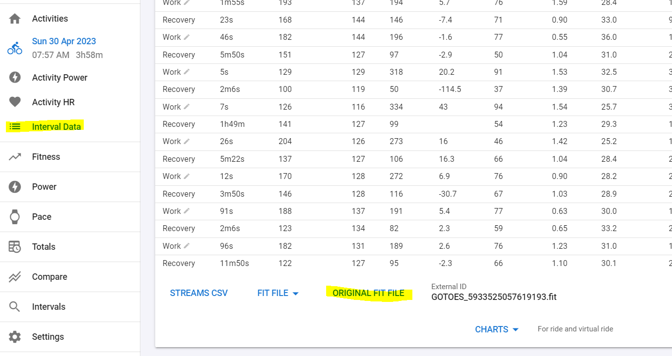
I can download the file but I get exactly what I had before using Intervals.icu:
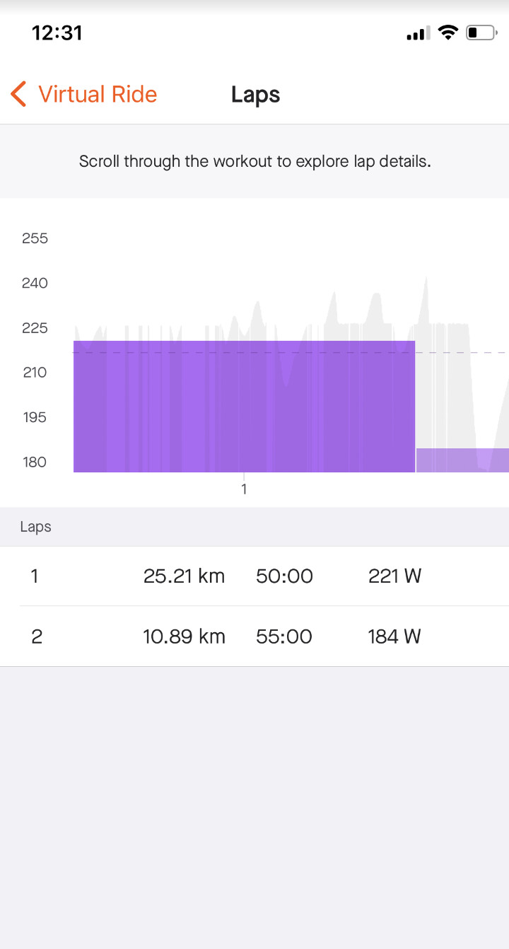
Only 2 laps, instead of the 10 laps I did originaly.
So if I understand correctly, Intervals and TrainingPeaks interpret the original file correctly, and Strava is faulty?
What did you use to record the indoor ride?
You should address the recording app or Strava.
You can eventually PM me a link to download the file and I will see what I can do.
Hi, I just messaged you the file.
I will contact Strava, thanks!
The indoor activity ride… was that done on Zwift? Or something else? What sort of route? Is it a VIRTUAL route?
Few things comes to mind…
if it’s an outdoor route, just riding indoors and there’s GPS data, Strava will use its OWN gps elevation data and override whatever the recording app provides.
eg: If I own a Garmin that does not have an internal barometer, Strava will utilise it’s own GPS elevation data and overwrite elevation.
If it does have barometer, then it will use the elevation data from the device.
SO, for my Breakaway: Indoor Training iOS app, i need to tell strava Explicitly to honor the elevation data from the FIT/TCX file. Otherwise, it will use whatever is the elevation data from it’s own database.
An Indoor Ride, if it’s an ERG power ride, will have 0m elevation, but since I do Virtual GPS, Stava, unless explicitly instructed, will utilise the Virtual GPS and it’s own Elavation database and put XXXm into it.
YOur Strava Screenshot doesn’t show a Device, so I can only presume that you do not have the “correct elevation” option because whatever you used to record the data, doesn’t have a barometer and thus, strava used it’s elevation database.
It’s a MyWhoosh Virtual ride with unknown GPS device. Your diagnosis is correct.
I used Gotoes on his file to set it to FullGaz Virtual, which solved the problem.
1 Like
Hmm… I didn’t know Strava also has exceptions for X apps.
I basically faked a Garmin Device w/ Barometer for Strava to take the elevation from the FIT file itself. (like now how I’m faking BreakAway: Indoor Training FIT files as coming from the TACX app so that Garmin Connect will recognise it and award those Garmin Badges and calculate Training Load etc)
Good To Know..
From the GoToes app:
FIT files: These can contain all sorts of data - including data that cannot be represented in GPX or TCX files. I have spent several months developing this option, and am now making it available early-access to my STANDARD tier Donation Supporters. ****** If you donated via Paypal before December 18, 2020, please use the contact link and write me with the PayPal email address you used to donate so I can send you a code for full-access to early-release features. Exporting as FIT will address the bug in Strava where a few GPS types aren’t displayed properly. Also, it opens up the possibility of you overriding the total calories when you export to Strava, total climbing, total distance, etc… Exporting from GOTOES as FIT gives you the maximum amount of control over your file exports.
Imported GPS File Types:
My tool attempts to auto-detect your GPS type. There are two relevant numbers: The MFR ID and the Product ID. If you upload a FIT file, it should have both of these numbers, and it will match up the GPS name with the numbers/names that I have entered in my growing database (see next paragraph for discussion on this). If you upload a TCX file, it only has the Product ID - not the MFR ID. This means that if Garmin gives their device an ID of ‘2002’ and Suunto gives their product an ID of ‘2002’, then my tool cannot tell them apart with just a TCX file. The FIT file is the only one that has the extra information to differentiate between the two. GPX files don’t have anywhere to officially store the GPS name information, however, my tool does try to search the file for clues to auto-detect GPS names. Sometimes it succeeds.
Getting a device added to the list:
There is no public list of the IDs, so I’m building it as we go along. If your device is not listed, Contact Me and I will add it. I’ll need for you to email me your TCX or FIT file (GPX files are of no use). I will also need for you to tell me which Make and Model GPS you have.
Strava Special Format
Strava has given us a non-standard way to transmit the GPS name information. Note that this is only promised to work with Strava, not other websites. I can embed the name in a TCX, GPX, or FIT file. The problem, though, with GPX and TCX is that Strava has been truncating the names. For example, if I tell Strava that the user has a ‘Garmin Fenix 6X Sapphire’, Strava is simplifying their database and only showing ‘Garmin Fenix’. I have been in contact with Strava to ask them to fix it, but only recieved automated replies so far. Fortunately, if I send to Strava as a FIT file, I can embed the MFR ID and the Product ID as discussed above. If you export using the FIT format from my tool, the device name on Strava should look the same as if you uploaded it directly from the device itself; that is one of the advantages of exporting in the FIT format. I have recently added FIT file export for my Donation Supporters. ******If you donated via Paypal before December 18, 2020, please use the contact link and write me with the PayPal email address you used to donate so I can send you a code for full-access to early-release features.
Before December 10 2022 climbing for my runs were correct, Intervals.icu showed more or less the same as Garmin and Strava. After December 20 climbing was suddenly way too high in Intervals.icu.
Strava and Garmin says about 65-70 meters for a 10k run. Intervals.icu says 395 meters. About 330 meters difference.
For another of my regular runs climbing is about 500 metets for a 15k run for Strava and Garmin. Intervals.icu says about 800 meters. Again around 300 meters too much.
Related?
1 Like
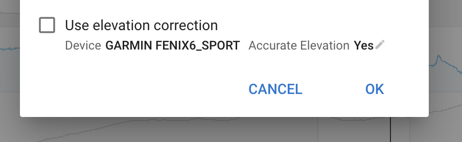
If you untick use elevation correction and choose accurate elevation it should work better (also for future activities). That said I am going to investigate because I would not expect the climbing calculated from the altitude data from the topo maps to be so different.
Have you considered that the difference is due to the internal Watch barometer? I know, at least for me, w a watch that has a wonky barometer, it can read 1000m elev gain when it should be like 10m Or such.
There’s also a possibility of impending storm or such that may ness w the barometer readings.
Just throwing some ideas.
1 Like
but OP here states that other sites seems to be pretty much in the rough ballpark number. 300+m different only on intervals.icu seems like an outlier.
@Christian wondering if you have set intervals to do “elevation correction” or otherwise?