Hi all,
I’m Darren. I’ve been building TourKit now for quite some time and, scary as it is - its time to open it up a bit wider than my colleagues and small group of testers. A cycling route planner that also has a training side.
This is part 1, the maps and the routing; the training side can wait for its own post. I’m looking for people who plan a lot of their own routes to try it and tell me where it goes wrong.
Routing
Pick road, gravel or mountain bike, and how quiet or hilly you want it. The router rates every road for traffic stress, from separated paths to busy, fast roads, using the Level of Traffic Stress model (Mekuria, Furth and Nixon, 2012), and routes on it (other models/cost functions are also included). You can see the result: colour the line by stress, surface, gradient or trail grade, and each route shows its share of low-stress kilometres.
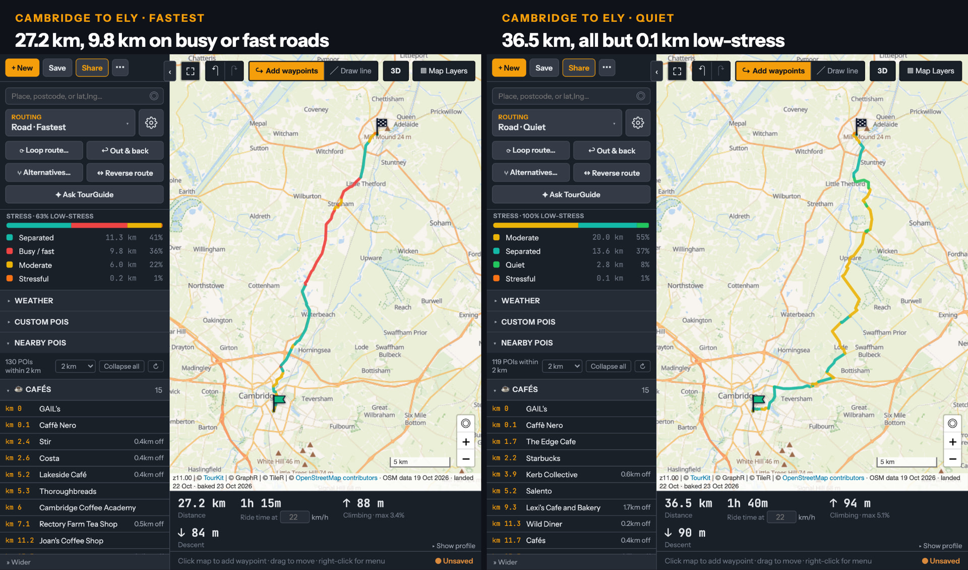
The picture above is Cambridge to Ely. The fastest route is 27.2 km, with 9.8 km of it on busy or fast roads. The quiet route is 36.5 km and 0.1kml low-stress.
It never asks you to get off and push: steps, footways without bike access and dismount sections aren’t routable at all. Ask for a loop of a set length from your door, or an out-and-back that comes home on different roads.
The routing engine is my own, written from scratch for TourKit. It isn’t built on an existing open-source router, and the map tiles and place search are TourKit’s own as well. The map data is OpenStreetMap, so where the mapping is wrong the route will be too. Those are worth reporting as well.
Before you ride it
Every route also tells you:
- each climb, categorised on the elevation profile
- the longest stretch without water, and the furthest you’ll be from a bike shop
- cafés, water and bike shops near the route, listed by the kilometre you reach them
- the forecast for when you’ll actually be there: how much of it is into the wind, when the rain comes, how cold it gets on the climbs, and whether you’ll finish before dark
- the climbs in 3D, before you get there
Tours
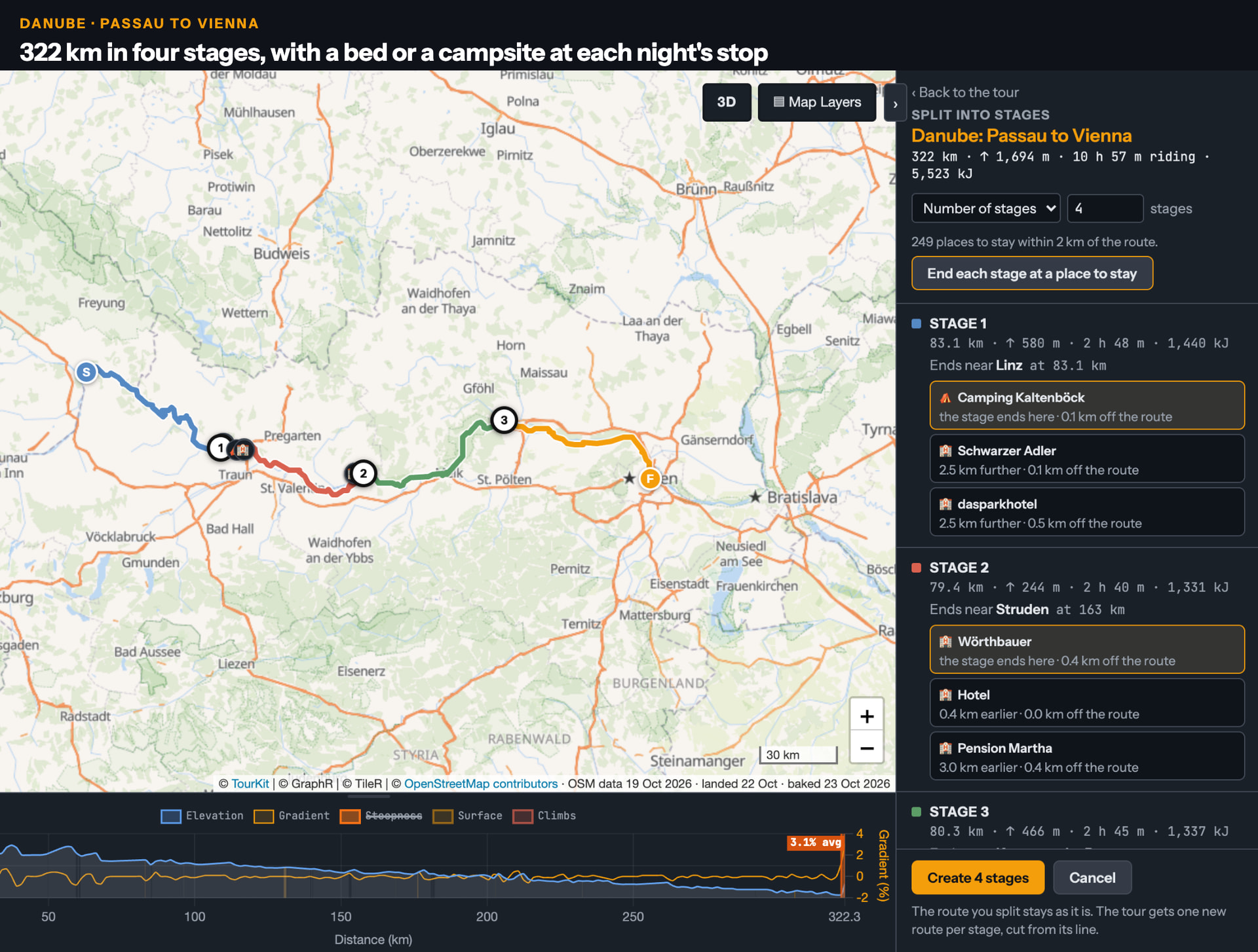
Split a tour into days, each ending near a bed or a campsite. Export any of it as GPX or FIT for whatever GPS you ride with.
Intervals.icu
Connect once and your rides come over, new ones about a minute after they land in Intervals.icu. Rides with GPS show on the map as your own heatmap, so you can see where you already ride while you plan somewhere new. Rides with power let TourKit work out your CdA and Crr, so Pacer can plan a route on your own numbers.
Access is read-only (activities and wellness), and nothing is written back. One gap: Intervals.icu can’t pass on rides it received from Strava. Rides from Garmin, Wahoo or a direct upload come through. TourKit is hosted in Germany; what it keeps and why is in the privacy policy
On the Edge and the phone
TourKit - Routes & Workouts is free on the Connect IQ store. Your routes arrive on the Edge as native courses, so turn-by-turn and ClimbPro work as they do for any course.
TourKit: Maps for iPhone is in App Store review and supports offline maps, offline routing and offline place search. I’ll post here when it’s out.
What would help most
Honestly - just play, find things, let me know where it breaks.
Accounts can be created at TourKit no card needed. Everything, Pro included, is free during the beta. I’ll announce pricing before the beta ends. Nobody is automatically moved onto a paid plan (should go without saying but want to be clear).
Thanks to David for the OAuth client.
Where do you plan your routes today, and what’s the one thing it gets wrong for you?
Darren