Hi there,
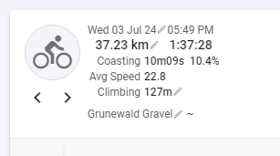
My activities recorded on the Wahoo Bolt often have the wrong number of elevation meters despite the barometric altimeter. If I now activate the altitude correction for an activity, a strange behavior occurs:
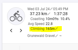
Now correct altitude after I disabled the correction again.
Comparison to the activity in Strava, which was also corrected using the build in Strava correction.
Strange behavior I would say…
I just read it. But from my point of view it doesn’t explain the behavior of the altitude correction function of intervals, particularly the correction provided by Strava seems to function correct
Those are all three from a different source…
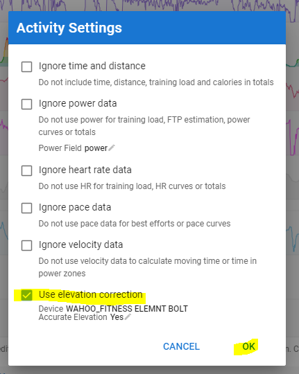
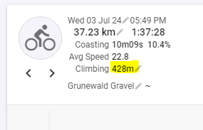
Initially, the field with total ascent in the FIT file is what your device has calculated from its built-in barometric sensor with its own algorithm and written to the dedicated FIT file field. If you ask Intervals to apply altitude correction, it will use the GPS coordinates to look-up altitude on cloud-available map services and it will calculate total ascent from those. If you now disable altitude correction, Intervals will use the altitude data that is in the FIT file to calculate total ascent with its own algorithm. And that isn’t the same algorithm as the one used by your device, hence the difference.
What I mean is that when you revert the situation, Intervals isn’t using the value anymore that was written in the FIT file by your device, but Intervals recalculates from the altitude data in the FIT.
Why are altitude algorithms all different?
It depends on what the dev is giving more importance. If you work without any hysteresis, you may end-up with dozens of ascent meters on a perfectly flat terrain, simply because the output from your sensor continuously jumps up & down from e.g. 6 to 7m. All those jumps would cause an increasing ascent number which isn’t correct.
If a bigger hysteresis is used, you have less of that up and down jumping. If it is too big, you have less ascent then what it should be. That’s the factor that is causing differences in between devices, software packages and calculation methods.
Thank you! This sounds logically to me. So intervals.icu has a better algorithm than wahoo to calculate the correct altitude collected on a ride.
So I would like to request a feature, which can recalculate the altitude with the intervals algorithm without applying the looked up altitude data, maybe as “batch command” for archived activities
Wouldn’t say that. It’s just different and may be better for some rides and worse for others. Rides with long sustained climbs are usually very well matching for all brands/devices/algorithms. Differences are more pronounced for rolling terrain, as explained above.