Hi @david,
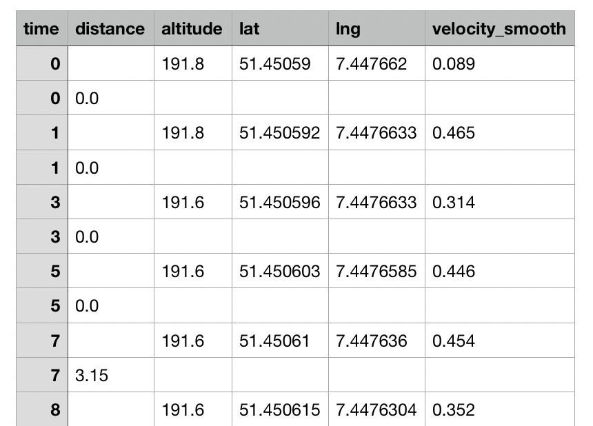
I just noticed, that intervals.icu incorrectly computes the total meters of elevation change for a Strava App recorded activity fit file (Intervals.icu). On Strava the elevation gain is 276m and on intervals.icu 2804m. The altitude and speed charts also show a sawtooth-like pattern, normal data points interleaved with zeros in the altitude chart. Strava generates two types of records and I assume you inject zeros in case the altitude field is not set. Maybe the preceding value should be used instead or ignored if a altitude value is already present for a timestamp.
214. record
 * enhanced_altitude: 189.0 [m]
 * enhanced_speed: 0.007200000000000001 [km/h]
 * gps_accuracy: 9 [m]
 * position_lat: ***** [deg]
 * position_long: ***** [deg]
 * speed: 0.007200000000000001 [km/h]
 * timestamp: 2021-07-17 09:37:51

215. record
 * distance: 0.04513 [km]
 * timestamp: 2021-07-17 09:37:51

216. record
 * enhanced_altitude: 189.0 [m]
 * enhanced_speed: 0.0036000000000000003 [km/h]
 * gps_accuracy: 9 [m]
 * position_lat: ***** [deg]
 * position_long: ***** [deg]
 * speed: 0.0036000000000000003 [km/h]
 * timestamp: 2021-07-17 09:37:52

217. record
 * distance: 0.04513 [km]
 * timestamp: 2021-07-17 09:37:52

218. record
 * enhanced_altitude: 189.0 [m]
 * enhanced_speed: 0.0036000000000000003 [km/h]
 * gps_accuracy: 9 [m]
 * position_lat: ***** [deg]
 * position_long: ***** [deg]
 * speed: 0.0036000000000000003 [km/h]
 * timestamp: 2021-07-17 09:37:53

219. record
 * distance: 0.04513 [km]
 * timestamp: 2021-07-17 09:37:53

220. record
 * enhanced_altitude: 189.0 [m]
 * enhanced_speed: 0.0036000000000000003 [km/h]
 * gps_accuracy: 9 [m]
 * position_lat: ***** [deg]
 * position_long: ***** [deg]
 * speed: 0.0036000000000000003 [km/h]
 * timestamp: 2021-07-17 09:37:55

221. record
 * distance: 0.04513 [km]
 * timestamp: 2021-07-17 09:37:55
Thank you in advance
Sven